The Bad Timing Tour
As always, the 1999 trip followed a theme. This year, we were beset with examples of our own bad timing. The week before we left, Oklahoma City and Wichita, KS, both directly on our projected path, had been hit by killer tornadoes. Throughout much of the trip it rained while we stopped, and then cleared up as soon as we left. We were constantly too late or too early or just "off-time" for events or attractions. but for all that, it was still enjoyable. For me, any time on the road is enjoyable, and time spent with Donna makes it doubly so.
The Route
Day 1—Houston, TX to Oklahoma City, OK
Day 2—Oklahoma City, OK to Pomona, KS
Day 3—Pomona, KS to Kansas City, MO
Day 4—Kansas City, MO to Jefferson City, MO
Day 5—Jefferson City, MO to Springfield, MO
Day 6—Springfield, MO to Texarkana, TX
Day 7—Texarkana, TX to Houston, TX
Donna and I both make entries in the journal, so my comments will be light blue and plain face, like this, Donna's will be pink and italicized like this and the route will be yellow and in plain face, like this. Let me restate that the notes here are just our impressions on one trip, so, if any offense is taken, none was intended.
I-45 North to
Dallas, TX
I-35 North to
Oklahoma City, OK
We left at 8:30 am, not quite so early as we wanted, but early enough. The traffic on I-45 was heavy until we got north of Conroe. Weird for a Saturday morning.
Pretty uneventful until we stopped in Huntsville at the Sam Houston Statue. It's 60 tons of steel and concrete designed by a guy who admits that it was "engineered without a blueprint." Oh, there's a large yellow ribbon tied around Sam Houston's cane. The statue is huge and looms above the highway, taking you by surprise when you crest the hill. The facility and picnic area are really pretty, though.
The drive from there to Dallas was boring, boring, boring. The only thing notable was that Dallas is re-doing all of the Interstate through downtown, and they're doing it all in a Santa Fe motif. Also, we noticed that they are building the overpasses first and the roads/ramps leading up to them after. We passed several of these overpasses to nowhere before I remarked that they had their own Stonehenge. Brett then commented that we'd figured out what the original Stonehenge was actually supposed to be.
Oklahoma had much better scenery. The Red River was blood red and amazing. There is a pimple in the landscape called the Arbuckle Mountains which was very pretty to drive through. Unfortunately, the area took only about 10-15 minutes to traverse.
When we got to the outskirts of Oklahoma City, we hit a traffic jam that was unbelievable. As it turns out, it was a slowdown for miles caused by rubbernecking of the tornado swaths. Absolutely nothing was left standing in a path about 100 yards across.
|
|
|
It's difficult to see in this photo, but the tornado had torn a swath about one hundred yards wide through the heart of Oklahoma City. |
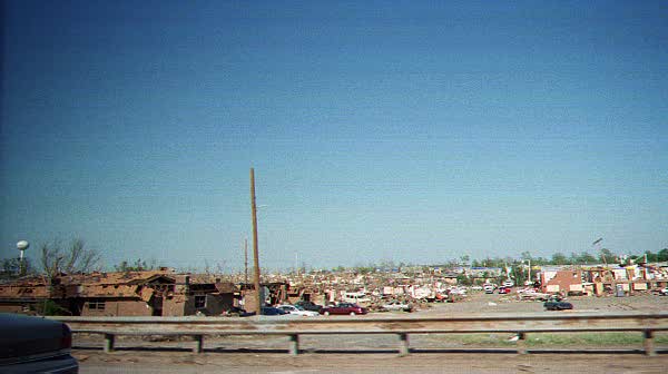
They have two exits of the freeway closed off to prevent sightseers. I was amazed at how there could be a path of such total destruction and just yards away, nothing was touched.
We were going to visit a monument to Commerce while in OK City, but it's closed on Sundays. Darn. Donna spent much of the night planning side trips for the next leg.
I slept during much of the trip to Dallas.
It strikes me that while many small towns spend all their time trying to be become big cities, Houston keeps trying to avoid the realization that it is no longer a small town. That's part of its charm: 4-1/2 million people who all want to believe they live in Hooterville.
I-35 North to
Guthrie, OK
US-77 North to
Mulhall, OK
OK-51 East to Perry, OK
US-77 North to
Blackwell, OK
I-35 North to
Mulvane, KS
KS-15 Southeast to US-77
US-77 North to
Florence, KS
US-50 East to Strong
City, KS
KS-57 North to
Prairie Nat'l Grasslands
KS-57 South to
Strong City, KS
US-50 East to I-35
I-35 North to US-75
US-75 North to KS-268
KS-268 East to Pomona Lake State Park, KS
[We]Left around 8:15 am and went in search of an ATM so we could get some cash. We got back onto I-35, but didn't stay there long because I wanted to exit through Guthrie, OK. According to the Roadside America website, their High School History Club was trying to raise money to get a decommissioned Russian battleship for their school parking lot, and I wanted to see if they had done it yet. They hadn't.
Instead of going back to the interstate, we took US 77 north through the countryside. As it turns out, along there between US 77 and I-35 was where the tornadoes moved through. We saw lots and lots of trees and debris in the fields on either side, mixed with pieces of twisted metal from buildings and downed power lines. When we reached Mulhall, we were diverted back to I-35 because of the damage there. [We later decided that the huge number of road closings was as much to prevent gawkers as it was to ensure safety.] Once we got back on I-35, we noticed where the tornadoes has gone there, too. The most interesting sight being the high-tension line carriers, you know, the huge metal structures that look like the Eiffel Tower? They were bent completely over so that the top of the tower was at the base of the structure. Wow!
We headed back to US 77 to get off of the interstate and wound around and through many towns that had Main Streets intact and thriving. Oh, I need to mention that Guthrie had a really awesome historic downtown. [It must be noted here that any town founded before 1970 has a "historic" downtown.] It looked as if their buildings had never fallen into disrepair and had always been occupied and kept up. There were other towns with Main Streets almost as good.
When we approached the Kansas border, we realized that we needed to get back on the interstate in order to hit the Kansas visitors' center. Even though the map we had showed that the visitors' center was right past the border, we found that it was actually twenty-five miles into the Kansas Turnpike—a toll road. We bought a magnet and some sunflower seeds in their gift shop and listened to the weather report.
Back onto US 77 again and we stopped in El Dorado. Actually, we stopped at the El Dorado Reservoir State Park—an Army Corps of Engineers project (one of many in Kansas). It was a nice little park, and we ate lunch the wandered around the nature trails for a while. We took stepping stones over the creek and overheard this conversation between some youngsters:
"Watch out when you put your feet in the water, the fish might bite them."
"That's not true."
"Yes it is. The fish think your toes are worms and might bite them."
I noticed as we went through more towns that someone had started this thing where the town's name is spelled out in white rocks up on the nearest hill visible from the highway. The first one was Florence, KS.
Brett caught a sign about a Federal Prairie Park and took us there. This was one of the things I especially wanted to see—a Tall Grass Prairie. There are a couple of parks in Kansas that have restored prairies, but this particular area was never farmed; it was only grazed so it remained intact. The Federal Parks Trust (not part of the government) actually owns 11,000 acres, and the Feds have 180 acres that have a farmstead and a small schoolhouse. The rangers were interesting to speak to, and the docent at the schoolhouse was fun, too.
The rest of the trip that day was just getting us to the campsite to bed down after a long day.
We stayed the night in Lake Pomona State Park. All of the State Parks in Kansas had a Mother's Day deal going where admission to the parks is free this weekend, so all we had to pay for was the camping. We arrived about six-ish as all the day users were leaving. Camping in mid-spring doesn't seem really big in Mid-America, and we found out why: the temperature got down into the fifties during the night, and we spent much of our sleep time adding more and more layers. [We had mostly light clothing and coverings with us, nothing that could efficiently stave off the cool alone.] It didn't help that the flu I'd been fighting off chose last night to attack.
KS-268 East to KS-68
KS-68 East to
Ottawa, KS
I-35 North to Kansas
City, KS
I-435 to US-71
US-71 to Belton, MO
At about 10 am we stopped so Donna could photograph the sign for the Great Plains Great Mall sign. If by "Great" they mean "large", they're gravely mistaken.
We arrived at the zoo at about eleven, bought our tickets and proceeded to wait for Gwyn. Zoo admission included a parking chit, so we walked up to the truck and (just to be safe) put the chit in the windshield. The security guy stopped us at the truck and asked us which part of Texas we were from. Apparently he's planning a move to Marshall and none of the real estate agents there will return his calls.
We mosied back down to the zoo gate where we were to meet Gwyn.
And it started to rain.
When it got going like it wasn't going to stop, Donna decided to get our umbrella out of the car. Imagine if you will, gentlemen, that you've been exchanging sexual banter and suggestive flirtation with a woman online for years. [Don't get me wrong, Gwyn and I are friends, and I would not, in a million years do anything inappropriate that might jeopardize that friendship, but boys and girls, she's a smokin' hottie.] Now imagine that the first time you get to meet her face to face, she arrives talking to your wife. Uncomfortable does not begin to describe the feeling.
|
|
|
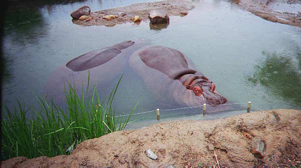
These pygmy hippoes were sent here from the Houston zoo a few years ago becaue the old hippo habitat was totally inadequate. The Houston zoo has a new habitat and new hippoes, now. |
We toured two sections of the zoo. Donna's better at describing locations so I'll just mention that it rained the entire time we were there. Just as were thinking about heading back to the cars from the far end of "Australia" [The zoo is laid out in "continents" and all of the animals in a particular section come from that actual continent.] it started raining in earnest. Even Donna was soaked.
Gwyn insisted that we stay at her house, which is a beautiful two-story in the surburbs with a gorgeous yard. We sat around and chatted and waited for Gwyn's boys to come home. They're great kids. E.J. , the eldest, is as sharp as a tack, and is amazingly polite for a nine-year-old. Corey, the 6-year-old is tiring to watch. He just keeps going. Even running head-first into walls at speed doesn't seem to faze him.
We had dinner at Appleby's, a Bennigan's knock-off with a more family flavor, and then went back to Gwyn's house. Once the boys were down for the night, I realized how sick I really was and took a nap. Donna and Gwyn stayed up chatting and poking around e-Bay. I awoke about midnight, just when Donna was going to sleep, so Gwyn and I stayed up a couple of hours chatting in her room. When I went to sleep around two-ish, I heard the TV in Gwyn's room come on.
The zoo was phenomenal. Very new, very well laid-out, and fun to investigate. If it hadn't been raining, the visit would have been much more enjoyable. The evening consisted of sitting around and talking. That was the best part.
US-71 South to
Harrisonville, MO
MO-7 South to
Clinton, MO
MO-52 East to
Windsor, MO
MO-52 East to US-65
US-65 North to I-70
I-70 East to Kingdom
City, MO
US-54 East to
Mexico, MO
MO-15 North to MO-154
MO-154 East to MO-19
MO-19 South to US 54
US-54 West to
Jefferson City, MO
This doesn't seem like a long way, but we didn't go directly. We headed to Windsor where Brett's maternal grandparents are buried. We were in luck when we reached the cemetery, because the caretaker was out and near the entrance, and we were able to ask him to steer us in the right direction. The Weiss area had six graves, one of which had been crushed by a fallen tree. The caretaker was very concerned that we had to see the damage before it was fixed, and he told us the city (owner of the fallen tree) was fighting with the insurance company about replacement of the stone.
We headed off toward Mark Twain's birthplace and stopped for lunch at a rest stop on I-70. Then we headed out and ended up stopping in Mexico, Missouri to tour the historical museums. Pretty typical stuff: big Victorian house filled with stuff from the early part of this century and the latter part of the last. [Usually donated to the city because the family that had owned it could no longer afford the upkeep.] The American Saddlebred Museum, which consists primarily of photos, award ribbons, and trophies, was attached to the house. The woman who took us through that section assumed that we were horse afficionados rather than shallow tourists. Brett discovered that you don't mention how stupid horses are to a horse-lovin' fanatic. The docent giving us the tour of the home, however, was interesting and pleasant to tour with.
We finally found Mark Twain's birth place, and spent some time going through the exhibits. The main part was the actual house maintained inside the park building—just like Sequoyah's home was in Oklahoma [Footnotes to History Tour]. Brett spent a few minutes convincing the park ranger that he was actually interested in Mark Twain and finally got her talking.
After we closed down that place, we headed south and west to Jefferson City, the Capital, where we spent a good night's rest and got a good long shower. We had originally planned to camp, but it had rained all day and we really didn't feel like fighting with it.
Paying admission is really big in Missouri. There are no "suggested donations". They tell you in two-inch-tall letters that you gotta pay to see it. I mentioned earlier about the zoo admission and parking fee. At Mexico, the woman who was so nice (not the irritating horse woman) was kind of cold to us until we assured her that we had, indeed, paid the two dollars (each) admission fee. Then she warmed right up.
Conversely, while we were paying the admission at Mark Twain's Birth Place State Park, the ranger went into "robot mode" while taking the money, giving us a thumbnail history of the house in a high-speed monotone. I think she used to read disclaimers for car-dealer radio commercials
In any case, I'm starting to think that Missouri isn't so much the "Show me" state as it is the "Show me the money" state. [In 1999, this was hilariously funny.]
US-63 South to MO-68
MO-68 West to St. James
MO-KK South to
Rositi, MO
I-44 West to Rolla, MO
1-44 West to Springfield, MO
We started a lot later today because it had rained really hard overnight -- thank goodness we didn't camp -- and we were kind of waiting for it to clear up before we started. Since we were in the Capital, we visited the Capitol building. What a beautiful place. The third Capitol, according to the literature, as the first one had burned to the ground and the second one had been hit by lightning and then burned to the ground. The place was full of school groups and the echoing noise was horrendous. By the time we left, the rain had started again.
We drove south toward Rolla, where Stonehenge is, and St. James, where wineries are. The road was really winding and steep in places and we were officially entering the Ozarks. It was a pretty drive, even in the rain. When we got to St. James, we stopped at the headquarters of the local rag to ask directions. We could tell this was a very touristy town because there were three local wineries and tons of "antique" stores. I guess this is where Missourians come for romantic weekends. Anyway...
The 4M Rossetti winery was merely a museum and outlet for every ceramic-painting, wreath-decorating, doll-dressing crafter in the area. There was hardly anything there worth notice, but we did buy some homemade jelly for a buck (it was clearanced -- probably last year's batch). The museum probably would have been more interesting if we had been shown the beginning of the tour, instead of the end of the tour. We toured backwards to the first display because the only person there was an older lady who couldn't (or wouldn't) really leave the gift area to give us the tour. This was once a working winery, but is no more. In addition, much of the equipment which was salvageable had apparently been moved to the working winery, so there wasn't really a feeling of a museum as much as a garage sale.
Having been disappointed by this place, we decided to head down the road and try the next place. Although there was no tour, there was wine-tasting and a much nicer gift shop. Also, the ladies running the place were friendly, helpful, and quite fun -- especially after the rush they experienced after an unexpected busload of senior citizens. Much better experience!
Off now to Rolla, home of the University of Missouri-Rolla (UMR) and their half-scale replica of Stonehenge. We had not one clue as to where on campus this was and drove around for a while before Brett thought to stop and ask in the Rock Mining Building. As it turns out, that was the right place to go. I spoke with the assistant to the professor who headed up the project for quite a long time. She told me about some of the other local interesting places and recommended Springfield as our stopping place for the night. This woman was extremely animated and knew a lot about the area. I got the feeling that she was excited that we were looking for Stonehenge and was tickled to give directions. When I asked about info on how it was carved (using high-pressure water-jet technology), she dug around in the file cabinets and found a xerox of a paper somebody wrote about it.
It was still raining, but luckily, just a little. We read all the plaques and took a couple of photos. It's actually Stonehenge, with a couple of modifications, a la Latin American natives and modern times, so that it is a daily calendar as well as an equinox-finder.
We headed inside the McNutt Building to gaze at the Mineral Walk -- a display of minerals that the Stonehenge lady had told me of. There were some cool examples of crystals and stuff. Once again, we closed down the place.
We got back on the road and ended up in Springfield for the night, watched "The Alamo" and got a good night's rest again. Oh, footnote -- there was a place that had about a million billboards for "Walnut Bowls" factory outlet battling with a place called "Ozarkland" (actually a chain, 'cause we saw two) along the major highways in Missouri. Also -- "NostalgiaLand".
We're learning that the beginning of May is a bad time for tourism. Every place that does school tours is crowded, because it's so close to the end of the school year that teachers don't want to start anything new (Kansas City Zoo was Field-Trip-O-Rama). Places that don't do schools are still working without their summer help, so they're busy gearing up for summer without the extra assistance they'll get later, and any attention received is often rushed and perfunctory (not that this should reflect badly on anyone).
US-65 South to
Little Rock, AR
I-40 West to I-430
I-430 South to I-30
I-30 South to AR-26
AR-26 West to Co 301
AR-26 West to AR-27
AR-27 South to US 278
US-278 South to I-30
I-30 West to
Texarkana, TX
We got another late start, but we didn't have that far to go, so it didn't matter -- we thought. We traveled south through the Ozarks toward Little Rock, Arkansas and found it took until 3pm. Between the curvy road and the slowpokes on it, we spent a greater part of the day there, going only about 250 miles. Because of that, we were unable to make Crater of Diamonds State Park before they closed. We did walk around and look at the field, which was black dirt (volcanic) and had no shade. It was also $4.50 a head to dig per day. The park had a feeling of greed attached to it. Pretty much a disappointment , all in all. On a bright note, though, we stopped at a gift shop for a famous Arkansas walnut bowl. We didn't buy one, although they were stunning. I did buy two trivets made of sliced walnuts, which looked like lace or etched wood. The ladies running the shop were quite friendly and told me about the elderly gentleman who is the craftsman. Apparently, this is how he supports himself, but he's independent enough to take his own sweet time when making them. There were also many whole-branch odds and ends that were kind of neat. I would have bought more, as the prices seemed very reasonable, except that I didn't have that much cash and they didn't take plastic. The owner did put her business card in the bag, though, and they do take personal checks. Hmmmm...maybe Christmas gifts for everyone.
The weather this day was absolutely perfect and the scenery was to die for. Lush green and clear blue sky. It's really too bad that we only stopped once, as there were many interesting places, like Old Washington State Park, which looked like a reconstruction -- kind of like Colonial Williamsburg. It did look "in progress", but there seemed to be enough there to be a good stop. There was also the Daisy BB factory tour and Sam's 5 & 10, which is supposed to be the original Wal-Mart -- sort of. Of course, these two visits would have been WAY off our beaten path. I think Arkansas deserves a roadtrip all its own. There are a couple of Civil War and archaeological sites that would be worth seeing. That would take a week in itself.
We're heading home tomorrow. It will be another long day, but hopefully, a fuller one than today.
We actually stopped several times: once at the Arkansas Information Station, which is a beautiful park,/rest area, situated in one of the most scenic areas of the Ozarks. The station and its park are, unfortunately, located in a hollow, so they have no view.
We also stopped at a truckstop on I-30 outside of Little Rock to go to the bathroom and get snacks. While in the Men's, I noticed they had a condom machine. The thing is, one of the choices on this machine was "Toys, Games, Pranks, Practical Jokes". I was aching with curiosity. I had to know what the suppliers of condom dispensers found funny. Unfortunately, the thing wouldn't take my money.
Day 7—Texarkana, TX to Houston, TX
US-71 South to I-30
I-30 West to US-59
US-59 South to
Houston, TX
Got a nice early start after a decent night's sleep. I think we're glad this is our last day. As it turned out, we did 2,195 miles, about 400 miles too much. I think we need to keep our trips between 1,500 and 1,800 from now on. We didn't make as many stops and spent a great deal of time on Interstates because we had a lot of ground to cover. Also, Brett thinks we took this trip too early, and I'm beginning to agree with him. Our first roadtrip was started Memorial Day weekend, the second over July 4th, and the others around the same time. There's a certain summer-vacation-feeling that didn't happen on this trip. Also adding to this being a bit disappointing was the weather being bad and not being able to camp every other night. I hadn't realized how much I enjoyed that, until now.
Anyway, we took off toward home, stopping in Marshall for gasoline and a stretch. Our next stop was to be the Dinosaur Museum, just outside of Moscow, Texas. Unfortunately, it's closed for good. The stegasaurus in the parking lot replaced the T-Rex we remembered seeing all those times back and forth to Lufkin with Lauren. Brett thought to stop and see how much they wanted for it, but we didn't. We did, however, hike the Woodland Trail that's not far from there that I always wanted to do. When we pulled in, that side of the highway was blocked off because someone pulling a trailer had not quite made it around to the highway and had ended up partially in the ditch. The Highway Patrol/Sheriff was blocking off the highway so they could extricate themselves safely. When we returned from the walk, an older couple was trying to straighten up the mess that pulling out of the ditch had caused inside the trailer. I kind of wanted to offer help, but decided not to.
We got back on the road and our next stop, our quest really, was for mayhaw jelly. We learned from the first roadtrip that mayhaw berries are shaken off the trees which grow near and on the banks of creeks. Luckily, the farmer's produce market which we always passed was open and had plenty of jelly.
When we got home, it was amazingly hot. Actually, it was quite a shock seeing as it was pleasant (in Texarkana) and the previous day, I'd been cold (Missouri and Arkansas). What a difference a few hundred miles and a swamp can make in the weather.
Next year, I'm going to suggest going back to Arkansas, but this time staying within the state and doing a more in-depth exploration. I picked up a brochure which gave all the major archaeological sites and Brett picked up one that was all the Civil War sites. But I'm repeating myself.
Summing up -- the trip was too long and too early. Aside from the day we spent with Gwyn, the trip was rushed and I felt we didn't really get to see a lot except highway. I missed talking to the local people and I really missed camping and getting to hike a little. It was sobering to see the tornado remains in Oklahoma. The Kansas City Zoo was amazing and the Prairie Museum was interesting, as was Mark Twain's birthplace. I wish I'd brought sleeping bags and I wish it hadn't rained on us. Oh, the ice lasted more than a day! We solved our cooler problem without having to buy a new one!